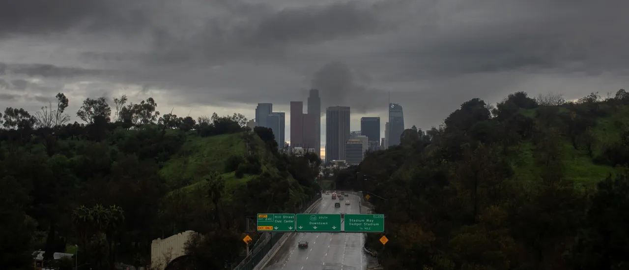
Authorities have issued evacuation warnings for at-risk zones in wildfire burn scars throughout the Greater Los Angeles metropolitan region in anticipation of an impending storm system that brings risks of flooding along with potential mudslides and debris flows, which may disrupt New Year’s Eve celebrations for millions of residents in California.
As much of the United States prepares to welcome 2026 with relatively tranquil weather, California faces a different outlook, with another significant storm during the holiday period expected to bring heavy rainfall to the Golden State, according to the FOX Forecast Center.
Los Angeles County has placed nine wildfire burn scar zones under evacuation warnings, effective starting Dec. 31 at 11 a.m. PST, among them a significant portion of Malibu devastated by the major Palisades Fire in 2024.
These evacuation warnings follow closely on the heels of widespread flooding that struck Los Angeles County only a week earlier, during a Christmas Eve that marked the highest rainfall total on record at Los Angeles International Airport and sparked sudden flash floods along with mudslides in various parts of California. (RELATED: Gargantuan Lake-Effect Snowstorm Setting Up For New Year’s Blast)
The flooding on Christmas Eve caused severe damage to a susceptible region in Wrightwood located within the Bridge Fire burn scar zone, an area now facing renewed dangers from potential mudslides and debris flows while under an evacuation warning.
Additional regions subject to evacuation warnings encompass the burn scar from the Canyon Fire around Halsey Canyon, the Kenneth Fire burn scar close to Calabasas, the burn scars left by the Agua Dulce and Lidia fires along Soledad Canyon Road in Acton, the Franklin Fire burn scar adjacent to Malibu Creek State Park, Kaslow Nature Preserve and the Malibu campus of Pepperdine University, the Eaton Fire burn scar in the Altadena vicinity, the Bridge Fire burn scar around Camp Williams and the East Fork San Gabriel River, as well as the Bridge Fire burn scar in the Mount Baldy area.
As reported by the FOX Forecast Center, intense rainfall linked to a diminishing low-pressure system from the subtropical Pacific is prompting flash flood warnings throughout large portions of Southern California, continuing into Thursday.
As the weather system progresses northward into Southern California, mild to moderate rain showers are forecasted to begin New Year’s Eve, with rainfall reaching its greatest strength New Year’s Day.
CALIFORNIA UPDATE: FOX Weather Meteorologist Craig Herrera gives us a behind the scenes look at what he is expecting out in California as another round of heavy rain is set to hit the west coast. Stay with FOX Weather for the latest: pic.twitter.com/Yc1ptS8UEh
— FOX Weather (@foxweather) December 30, 2025
With rainfall amounts on the rise and soils already thoroughly soaked, a level two out of four flash flood threat remains in effect from Wednesday into Thursday.
The threat covers zones stretching from Los Angeles northward to Santa Barbara, areas that have lately seen record-breaking downpours with accumulations surpassing one foot in certain spots.
By Friday, the risk of flash flooding moves farther northward along the California coastline, extending to parts of Northern California that include San Francisco.
Currently, an additional broad accumulation of 1-2 inches of rainfall seems probable for much of the area extending through Friday, while certain spots in California’s Transverse Ranges could experience localized totals of 2-3 inches or higher, per the FOX Forecast Center. (RELATED: Multiple Semi-Trucks, Over 50 Cars Get In Pile-Up Crash On I-75 In Michigan Amid Life-Threatening Winter Storm)
After the current system moves out, a more substantial and possibly stronger storm is forecasted to arrive in Northern and Central California starting Friday and extending through Saturday. This upcoming weather event may deliver gusty winds, significant rainfall, and additional heavy snowfall across the Sierra Nevada mountains.
Although the precise schedule and extent of impacts are still unclear, forecasts are expected to become more accurate over the next few days.
Nearly all of California’s coastal areas are currently facing a minimal-level flash flood threat Friday, extending into the early hours of Saturday. Affected locations include San Francisco, Santa Barbara and Redding.
The Climate Prediction Center is maintaining its forecast for higher-than-normal precipitation probabilities across the western United States extending into the beginning of January.


![Donald Trump Slams Chicago Leaders After Train Attack Leaves Woman Critically Burned [WATCH]](https://www.right2024.com/wp-content/uploads/2025/11/Trump-Torches-Powell-at-Investment-Forum-Presses-Scott-Bessent-to-350x250.jpg)

![Texas Trucker Busted with 23 Illegals Stuffed into the Cab of His Big Rig [WATCH]](https://www.right2024.com/wp-content/uploads/2025/12/Texas-Trucker-Busted-with-23-Illegals-Stuffed-into-the-Cab-350x250.jpg)