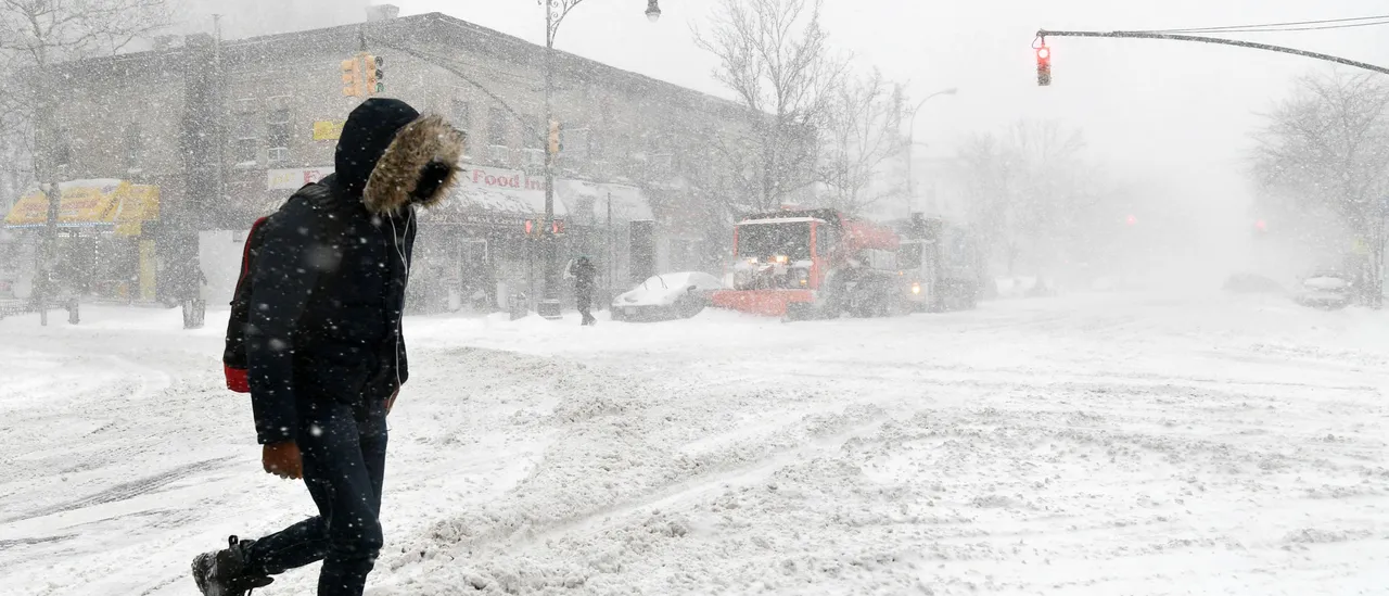
A storm along the East Coast that’s expected to develop into a nor’easter this weekend has the potential to rapidly intensify into a bomb cyclone, possibly bringing heavy snowfall, hurricane-force winds, and localized coastal flooding from the Carolinas northward through New England — regions still recovering from the impacts of Winter Storm Fern.
The Weather Channel has officially designated this system as Winter Storm Gianna.
As is typical with storms on the East Coast, multiple critical uncertainties persist with a few days remaining in the forecast period. Be sure to check back consistently with the Daily Caller for the latest updates and refinements as the weather pattern evolves in the coming days.
By Friday night, snowfall could begin across portions of the Southeast while a low-pressure system starts to organize and strengthen off the coast. (RELATED: Polar Vortex Brings Rare, Historic Deep Freeze To Florida; Miami Could See Lowest Temperatures In 16 Years)
The storm is expected to intensify across the Southeast coastline Saturday, generating snow and steadily increasing winds.
Sunday marks the storm’s peak, when it is forecast to reach maximum strength. Expect the strongest winds of the event, along with the potential for heavy snowfall and flooding on the coast.
The storm is projected to linger Sunday night in areas of eastern New England before shifting away Monday.
Winter Storm Gianna has been named and will be the nor’easter set to impact the East Coast this weekend. The track is still uncertain, so please check back here often. Here’s the latest: https://t.co/3bQOTUzAyP pic.twitter.com/FuG81ajRfQ
— The Weather Channel (@weatherchannel) January 28, 2026
The highest chances for significant snowfall accumulations courtesy of Winter Storm Gianna are seemingly concentrated in two regions.
The first area stretches from southern Virginia through North Carolina, with the potential to extend into portions of South Carolina.
The second area of concern is eastern New England. Some locations in this region could see additional notable snowfall, adding on to the more than 20 inches from Winter Storm Fern.
The precise path of the strengthening low-pressure system off the East Coast will ultimately determine how widespread and heavy the snowfall becomes across the coast. At this stage, that track remains uncertain. (RELATED: Northeast Facing Potential Nor’easter Threat After Historic, Deadly Winter Storm)
Should the low stay offshore far enough, the majority of the heaviest snow could potentially be pulled out to sea north of southern Virginia.
Conversely, a track closer to the coastline could allow more significant, wind-driven snow to impact a larger portion of the Eastern Seaboard.
With the overall strength of the system, two primary threats stand out with high confidence for this weekend, however, precise information is still evolving at this early stage.
A dangerous, hurricane-force blizzard will likely be uncomfortably close to the U.S. East Coast this weekend.
There will be some forecast changes going forward, but the signal is becoming clearer. pic.twitter.com/YXcPaAqAA0
— Greg Postel (@GregPostel) January 28, 2026
Winds represent one of the biggest hazards. Strong, potentially damaging winds are expected to affect at least portions of the East Coast, stretching from North Carolina’s Outer Banks northward into New England. These winds could lead to power outages and tree damage in some areas. The exact locations and inland extent remain uncertain, and will depend on the storm’s track and intensity. That said, this system has the possibility of producing significantly stronger winds than those felt during Winter Storm Fern.
Coastal flooding is the other key concern. Flooding at high tide appears likely across sections of the East Coast this weekend from the northern Outer Banks up through New England. As with the wind threat, specifics are uncertain and are subject to change given the forecast distance.
The Weather Channel has confidence that the low-pressure system developing off the Eastern Seaboard will ultimately intensify.
The strengthening could occur rapidly enough to qualify the storm as a “bomb cyclone” — a meteorological term used to describe a low-pressure system that’s intensifying quickly. (RELATED: Massive Winter Storm Leaves At Least 18 People Dead, 800,000 Without Power)
Although the name sounds dramatic, bomb cyclones are fairly common along the East Coast during the colder months, typically once per winter season. They draw energy from the sharp temperature contrast between frigid air across land and the warmer waters of the Atlantic Ocean.
This particular system is also expected to evolve into a nor’easter, a type of East Coast storm characterized by northeasterly winds blowing ahead of (to the north of) the low-pressure center.
Check back with the Daily Caller as we continue to track Winter Storm Gianna.


![Donald Trump Slams Chicago Leaders After Train Attack Leaves Woman Critically Burned [WATCH]](https://www.right2024.com/wp-content/uploads/2025/11/Trump-Torches-Powell-at-Investment-Forum-Presses-Scott-Bessent-to-350x250.jpg)

![James Carville Admits Democrats Had No Shutdown Endgame, Mishandled Strategy [WATCH]](https://www.right2024.com/wp-content/uploads/2025/11/1763070634_James-Carville-Admits-Democrats-Had-No-Shutdown-Endgame-Mishandled-Strategy-350x250.jpg)