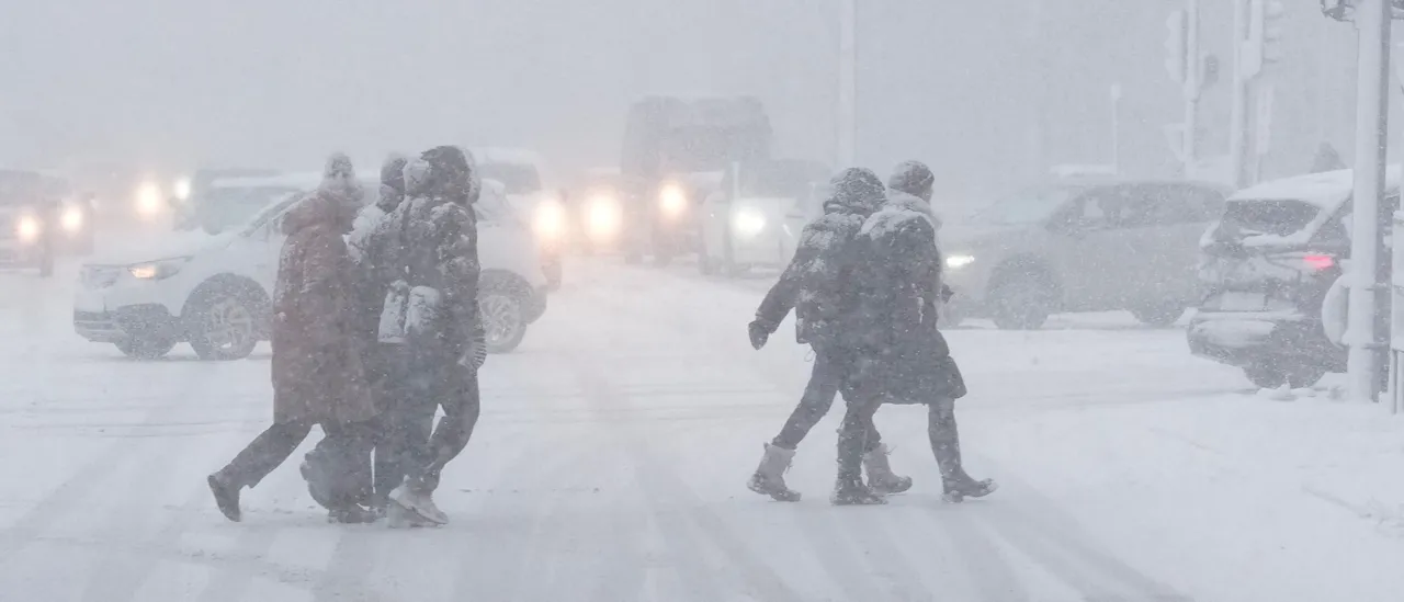
A sprawling winter storm with the potential to become historic is forecast to affect over 235 million Americans across more than 40 states, stretching from Arizona all the way to Maine. The system is expected to span over 2,000 miles and bring severe snow and ice accumulations starting Friday.
A powerful follow-up surge of Arctic air tied to the polar vortex will follow closely behind, creating dangerous refreezing conditions that could lead to prolonged power outages and bring travel to a near standstill for several days, according to the FOX Forecast Center.
Arkansas, Virginia, and Georgia have now declared states of emergency, joining North Carolina and South Carolina in preparing for the massive storm. Texas Gov. Greg Abbott issued a disaster declaration Thursday covering over 130 counties.
Utility companies in the affected regions have already begun mobilizing extra crews, bracing for heavy ice buildup that could bring down power lines and render roadways virtually impassable. (RELATED: Polar Vortex Now Has Millions In Over 35 States Threatened By Potentially Historic, Catastrophic Winter Storm)
States across the Interstate 95 corridor in the Mid-Atlantic and Northeast are gearing up for the possibility of over a foot of snow, which would mark one of the most significant snowstorms in years.
The expansive system is expected to emerge Friday morning from the Southwest and push steadily eastward throughout the weekend. It will first strike Texas and Oklahoma, then sweep along the South before moving through the Mississippi and Tennessee valleys, ultimately hitting the Mid-Atlantic and Northeast coastal areas.
Airports nationwide are likely to experience multiple days of widespread cancellations and major delays as the storm disrupts air travel across large portions of the country.
Widespread Preparations Underway As Historic Storm Approaches
Arkansas and Virginia issued states of emergency Thursday afternoon as additional Winter Storm Watches and Warnings continued to be posted in multiple regions nationwide by the National Weather Service (NWS).
Thursday morning, Georgia Gov. Brian Kemp issued a state of emergency. The order will remain active into next Tuesday.
Texas activated its state emergency response resources Wednesday. Then, Gov. Abbott issued a disaster declaration Thursday covering 134 counties and encouraged all residents to finish their storm preparations prior to Friday night.
South Carolina activated its Emergency Operations Plan, a measure that empowers state agencies to rapidly deploy resources and enables the state’s National Guard to activate personnel and ready equipment.
I’ve declared a State of Emergency as North Carolinians brace for winter weather this weekend. The State Emergency Response Team is already working to make sure resources are in place to keep folks safe.
Now is the time to be prepared and get everything you need in advance of…
— Governor Josh Stein (@NC_Governor) January 21, 2026
North Carolina Gov. Josh Stein announced that the state’s emergency response team is already actively coordinating to ensure all necessary resources are prepositioned and ready to protect residents.
Alabama Gov. Kay Ivey has joined other Southern governors in declaring a state of emergency, issuing the order for 19 northern counties.
“In Alabama, we are no stranger to Mother Nature. However, when it comes to winter weather, we are not as familiar,” said Gov. Ivey in an official press release. “So, as we head into this weekend, I am urging my fellow Alabamians, especially in the northern part of our state, to stay weather aware.”
A state of emergency for 19 northern counties is now in effect.
As we head into this weekend, I am urging my fellow Alabamians, especially in the northern part of our state, to stay weather aware.
Y’all, stay safe, stay warm and stay weather aware. #alwx #alpolitics pic.twitter.com/hFOT2WbP0b
— Governor Kay Ivey (@GovernorKayIvey) January 22, 2026
Tennessee Gov. Bill Lee has declared a state of emergency across all 95 counties in the state.
“We encourage all Tennesseans to check local weather conditions and follow kep updates from state agencies,” said Lee in a statement.
Today, I issued a state of emergency for all 95 counties ahead of this weekend’s major storm.
We encourage all Tennesseans to check local weather conditions & follow key updates from state agencies: @TennesseeEMA@myTDOT@TNHighwayPatrol
Learn more here:… pic.twitter.com/jChtyv7ohm
— Gov. Bill Lee (@GovBillLee) January 22, 2026
Southern Tier Braces For Life-Threatening Ice Storm
A crippling ice storm is projected to be the dominant hazard across the southern portion of this massive winter weather system.
More than 15 states along an expansive corridor — from New Mexico into the South towards the Carolinas and coasts of the Mid-Atlantic — face the risk of significant ice buildup from Friday through Monday. Accumulations could be heavy enough to trigger widespread power outages.
Winter Storm Warnings are now in effect for cities including Nashville, Tennessee, and Little Rock, Arkansas.
BIG IMPACT STORM ❄️: A potentially historic winter storm is expected to sweep through 40 states in the U.S., affecting over 250 million people. Here’s the latest:#winter #winterstorm #history #snow #FoxWeather pic.twitter.com/tlaAd9IrQ8
— FOX Weather (@foxweather) January 22, 2026
The primary zone expected to experience the most severe ice accretion — likely resulting in extensive power outages — stretches from East Texas across southern Arkansas and northern Louisiana into northern Mississippi.
Residents of the Dallas-Fort Worth metropolitan area should also get prepared for dangerous icing conditions that are forecast to develop starting Friday.
Another major ice risk is anticipated along the eastern slopes of the Appalachians, currently projected to affect areas including Atlanta and Augusta in Georgia, and Charlotte, North Carolina.
Winter Storm Poised To Strike Southern Plains Friday, Paralyzing Travel Conditions Expected Saturday
Cold rain is forecast to develop from Dallas to Little Rock by Friday afternoon, then change over to a hazardous wintry mix of precipitation by Friday evening.
The storm’s most intense phase is projected to occur Saturday morning into the day, bringing widespread and dangerous icing from Midland, Texas, across Dallas and extending into Little Rock. These icy conditions are expected to linger into Monday.
Snow will accumulate across a broad area from the Texas Panhandle northward through Kansas and Missouri. The heaviest snowfall is anticipated between Interstates 70 and 40.
The Hurricane Hunters are flying into the setup of this weekend’s massive winter storm. @JimCantore and @NWSDirector explain how this mission provides life-saving data: pic.twitter.com/hk7NE20h2V
— The Weather Channel (@weatherchannel) January 22, 2026
A large region is expected to see 5-8 inches of snow from central Oklahoma through northern Arkansas into Sunday. This includes major metropolitan areas such as Wichita, Kansas, Oklahoma City and Tulsa, Oklahoma, and Kansas City, Missouri, with some snowflakes reaching as far north as Chicago, Illinois.
This winter storm has the possibility to rank among the top five biggest single snowfall events ever recorded in the history of Oklahoma City.
While the storm progresses further through the Southeast, a deep freeze will stay entrenched across the Southern Plains, not allowing existing snow and ice to melt. This could possibly complicate and delay any efforts to restore power.
Storm Enters Southeast Saturday, I-40 And I-20 Corridors At Risk Of Severe Icing
The enormous winter storm is forecast to arrive in the Southeast by Saturday morning, as a powerful high-pressure system becomes anchored across the Northern Plains and Midwest to the north.
This clockwise-rotating high will channel a deep surge of Arctic air southward, trapping it against the Appalachian Mountains and creating ideal conditions for severe icing from Atlanta northward to Charlotte, North Carolina.
Substantial ice accumulations are also anticipated through northern Alabama and West Tennessee. Hazardous driving conditions are expected farther south along Interstate 20.
Milk, bread, and salt are flying off shelves in Oklahoma City. Across the country, communities are preparing for a major winter storm.
See when the storm arrives and how it could impact you: https://t.co/kTlOwAovaQ pic.twitter.com/dWXdgBgfNI
— AccuWeather (@accuweather) January 23, 2026
Uncertainty persists about the precise locations where freezing rain will dominate against sleet, which generally poses far less risk to power lines and infrastructure.
Overall, the storm track has moved noticeably more north compared to earlier model guidance this week. As a result, the heaviest snow is now expected to remain north of Interstate 40, while I-40 itself faces the prospect of extended periods of almost impossible travel because of dangerous icing.
The most significant snowfall is projected across Cumberland Plateau in Tennessee and possibly through the southern Appalachians of western North Carolina. Kentucky is forecast to receive 5-8 inches of snow across much of the state, with isolated areas possibly seeing up to a foot.
Mid-Atlantic And Northeast Brace For Potentially Record-Breaking Snowstorm
Computer forecast models (American GFS|European ECMWF) are showing increasing agreement that this system has the potential to become the most substantial snowstorm to affect portions of the Mid-Atlantic and the New York tri-state region in several years.
There is growing confidence that the mammoth winter storm could merge with a weather disturbance from the Northern Plains, resulting in a more intense system developing off the East Coast.
Should this merger occur, New York City, Philadelphia, and parts of New Jersey could accumulate over a foot of snow by Monday morning.
The exact nature of the interaction between the two systems will ultimately dictate whether snowfall totals end up around 8 inches or climb as high as 16 inches. (RELATED: Millions Of Americans In Over 30 States To Get Blasted By Potentially Historic, Catastrophic Winter Storm)
Winter Storm Watches are now in place across most of the Interstate 95 corridor, encompassing major population centers including New York City and Boston.
The system is expected to arrive in the area by Saturday night, reach its peak intensity Sunday, and gradually taper off Monday.
At present, the heaviest projected snow accumulations are centered from central Virginia northward into Washington, D.C.
The further north the storm track shifts, the higher the probability becomes for major snowfall extending up the Interstate 95 corridor through New England.


![Donald Trump Slams Chicago Leaders After Train Attack Leaves Woman Critically Burned [WATCH]](https://www.right2024.com/wp-content/uploads/2025/11/Trump-Torches-Powell-at-Investment-Forum-Presses-Scott-Bessent-to-350x250.jpg)


![CNN's Kaitlan Collins Fact-Checks Rep. Jasmine Crockett Over False Trump Ballroom Claim [WATCH]](https://www.right2024.com/wp-content/uploads/2025/10/1761954330_CNNs-Kaitlan-Collins-Fact-Checks-Rep-Jasmine-Crockett-Over-False-Trump-350x250.jpg)